Contents
The United Arab Emirates (UAE) is located in the southeastern part of the Arabian Peninsula in Southwest Asia. It is bordered by Oman to the east and Saudi Arabia to the south, as well as sharing maritime borders with Qatar and Iran. continoue reading to know more about geographical aspect of UAE
UAE climate
when we want to speak about UAE geography , we need to clarify the climate of UAE. United Arab Emirates is a desert climate with hot summers and mild winters with pleasant weather. Summers are extremely hot, with temperatures often exceeding 40 °C (104 °F), while winters are relatively cooler, with average temperatures ranging from 14 to 24 °C (57 to 75 °F).
UAE geographical aspect

The geographical features of the UAE are many. Some areas are located on the coast, and mountainous, some of them are surrounded by the desert to be green oases. The following mentions 5 of UAE geography phenomena:
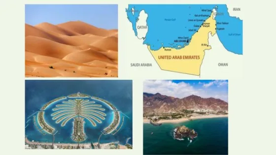
- Deserts: Most of the interior regions of the UAE geography consist of vast deserts, especially the Arabian Desert. The Empty Quarter, also known as the Empty Quarter, is one of the largest continuous sandy deserts in the world and occupies a large part of the southern United Arab Emirates.
- Coastal areas: The United Arab Emirates has a long coastline extending along the Persian Gulf to the north and east. The coast is characterized by sandy beaches, wide coastal plains and many offshore islands
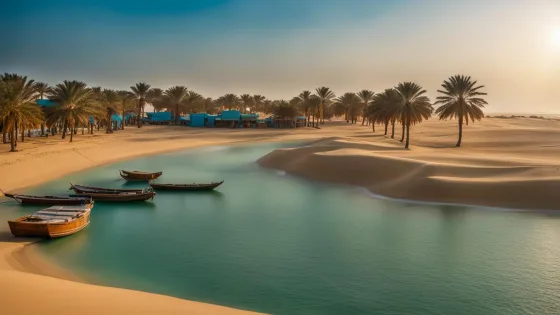
- Oases: Within the desert areas in UAE geography, there are separate oases that provide a source of water and support some agricultural activities. These oases are formed around natural springs or through groundwater extraction. The city of Al Ain is a green oasis and is home to the Green Mubazzarah.
- Mountains: The eastern part of the UAE geography is home to the Hajar Mountains that run parallel to the Gulf of Oman. Located in Ras Al Khaimah, Jebel Jais is the highest peak in the United Arab Emirates, reaching a height of 1,934 meters (6,345 feet). The mountains provide a scenic backdrop and are popular for hiking and outdoor activities.
- Islands: UAE geography is home to many natural islands, such as Abu Musa, Greater and Lesser Tunbs, and artificial islands such as The Palm Island.
read more: Business Activity UAE; Business activities in Dubai UAE
Biodiversity
United Arab Emirate has four main ecosystems: desert, sea, fresh water, and mountains. read more to know about main 3 ecosystem which related to UAE geography
Desert ecosystem

habitats are located in the arid tropics and show growth of a few species of seasonal plants. The desert environment is currently undergoing major changes as a result of the huge afforestation projects launched by the state and the spread of desert farms.
read also: UAE air pollution; sources, causes, and all you need to know
Marine ecosystem

This part of UAE geography include Gulf and Arabian Sea regions, and both have important ecosystems, including islands, coral reefs, sea grasses, inter tidal zones, salt marshes, creeks, and mangroves. As for fresh water resources, they are scarce, but they can be found in the form of groundwater or hot springs, and there are also available Numerous sabkhas (stagnant salt water) and artificial lakes, which form wet ecosystems.
The marine life in the United Arab Emirates is also rich in fish, plants and coral reefs. There are more than 500 different species of fish living in the waters of the Persian Gulf, with many found in the Indian Ocean. The Arabian Gulf is also blessed with good numbers of dolphins, and sea turtles.
see also: UAE visa fees; how to apply, and all you need to know about it
mountain ecosystem

Mountains in the UAE constitute 2.6% of total UAE geography, separating the Sea of Oman in the east and the sand dunes of the Arabian Gulf in the west. They are 155 km long, the most important of which are the Hajar Mountains, which act as rain catchment areas. Surface water runoff in the region is the only source that feeds groundwater. The rugged Hajar Mountains rise sharply to a height of 2,000 metres, and dry river valleys carve the mountains into fertile plains
what are the three main UAE geography characteristic ?
The UAE is divided into three geographic regions: a flat, low-lying and arid coastal plain. Sand dunes extend from the coast to a vast desert land that merges with the Empty Quarter desert
How many countries have borders with the UAE?
The UAE is bordered to the north by the Arabian Gulf, to the east by the Gulf of Oman and the Sultanate of Oman, to the south it is bordered by the Kingdom of Saudi Arabia and the Sultanate of Oman, and to the west by the State of Qatar and the Kingdom of Saudi Arabia. The length of the land borders with neighboring countries is 876 km.
What are the geographical coordinates of the UAE?
UAE geography coordinate between Longitude: 51°35′ – 57°10’E and Latitudes: 22°35′ – 26°25’N
you can read also: UAE golden visa: amazing benefits for obtaining it you may don’t know about
In the conclusion, we mentioned the most important points for UAE geography as well as the terrain structure of the Emirates. There are a diversity of terrain in its structure, and the desert has the largest proportion of its lands, followed by plains, mountains and islands