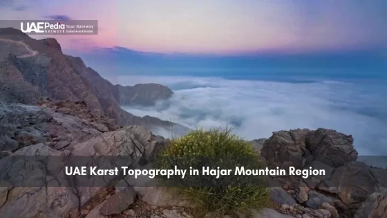
Did you know the same forces that shape tropical caves created the Middle East’s most striking desert landscapes? The Hajar Mountains hide a geological secret: intricate rock formations carved by nature’s patient hand over millennia.
These mountains tell a story written in limestone. Rainwater, slightly acidic from absorbing carbon dioxide, slowly dissolves the rock. This process – called karstification – creates caves, sinkholes, and jagged ridges. It’s a dance between chemistry and time, visible in every weathered cliff face.
Modern engineers face puzzles here. Building roads through ancient rock requires balancing progress with preservation. Meanwhile, adventurers find natural amphitheaters and hidden wadis perfect for sunrise hikes. We’ll show you where science meets exploration.
This guide blends local knowledge with geological marvels. You’ll discover:
- How to spot subtle karst features during your next mountain trek
- Why certain rock layers crumble while others stand firm
- Expert tips for photographing these formations at golden hour
Pack your curiosity – we’re mapping nature’s artwork across the united arab emirates’ wildest terrain.
Overview of the Hajar Mountain Region and Karst Landscapes
Stretching like a dragon’s spine across the eastern frontier, the Hajar Mountain Region reveals Earth’s memory in layered limestone. This 700-km belt – shared between two nations – cradles wadis deeper than skyscrapers and peaks reaching 3,000 meters. Its geology acts as a time capsule, preserving 250 million years of planetary drama.
Rock Libraries & Natural Architecture
Three features define this rugged wonderland. First, jagged anticlines – upward-folded rock layers – create sawtooth ridges visible from space. Second, honeycombed cliffs show where water patiently carved Swiss-cheese patterns. Third, dry riverbeds (wadis) expose fossil-rich sediments perfect for amateur paleontology.
When Oceans Ruled the Desert
Long before dunes formed, this area lay under shallow seas. Marine creatures’ skeletons built limestone deposits thicker than 5 km. Tectonic collisions later thrust these seabeds skyward, creating the mountains we see today. Rain then began sculpting the stone into today’s labyrinthine forms.
| Geological Period | Key Events | Visible Features |
|---|---|---|
| Permian-Triassic | Shallow marine sedimentation | Fossilized coral reefs |
| Cretaceous | Tectonic uplift begins | Fold mountains |
| Quaternary | Erosion shapes karst | Caves & sinkholes |
Bedouin oral histories still reference these formations, proving how geology shapes culture. Next time you hike here, touch the rock – you’re literally grasping eons.
Understanding the Basics of Karst Topography
Ever wonder how nature sculpts those jaw-dropping rock mazes you find while hiking? Let’s break down Earth’s slow-motion art class. When rainwater becomes slightly acidic – think of it grabbing carbon dioxide from the air like a sponge – it starts dissolving certain types of stone. This is where the magic begins.
Definition and Key Processes
Picture this: water + carbon dioxide = weak carbonic acid. When this cocktail trickles through cracks in limestone, it eats away at the rock like invisible termites. Over centuries, this creates:
- Clints (flat stone pavements)
- Grikes (deep grooves between clints)
- Hidden caves beneath your feet
The real star here is surface water. It doesn’t just vanish underground – it reshapes entire landscapes. Sinkholes form when cave roofs collapse. Underground rivers carve twisting tunnels. And those jagged ridges? They’re nature’s leftover crumbs after the watery feast.
Here’s the kicker: this isn’t some rare phenomenon. From your local creekbed to tropical islands, these processes work anywhere limestone meets moisture. Next time you spot pockmarked rocks during a hike, you’ll recognize nature’s chemistry set at work.
Ready to decode more rocky riddles? Let’s explore how these silent transformations create the dramatic vistas beneath our boots.
A Deep Dive into UAE Karst Topography Formation
Imagine nature’s kitchen where water and stone bake geological wonders. Hidden beneath dramatic cliffs, a silent chemical ballet transforms solid carbonate layers into labyrinthine caves. Let’s break down the recipe behind these jaw-dropping formations.
The Chemistry of Disappearing Rocks
Here’s the secret sauce: rainwater becomes a mild acid when it absorbs carbon dioxide from air and soil. This fizzy cocktail – called carbonic acid – eats through carbonate rocks like invisible sandpaper. The reaction works like this:
- Water + CO₂ → H₂CO₃ (carbonic acid)
- Carbonic acid + calcium carbonate → dissolved minerals
This process leaves behind pockmarked surfaces and underground tunnels. Over centuries, these small changes create cathedral-like caves and razor-sharp ridges.
Nature’s Sculpting Team
Three partners shape these landscapes:
| Element | Role | Impact |
|---|---|---|
| Water | Acid carrier & solvent | Creates drainage patterns |
| Carbon Dioxide | Acid catalyst | Speeds up erosion |
| Marine Minerals | Reactive ingredients | Determine erosion speed |
Ancient marine environments left behind calcium-rich deposits that now react with modern rainfall. This blend of old and new explains why some cliffs crumble faster than others. Coastal humidity adds another layer – salt crystals grow in cracks, wedging rocks apart like natural crowbars.
These processes never stop. Even today, morning dew teams up with desert winds to reshape cliffs millimeter by millimeter. Next time you spot honeycombed stones, you’ll see Earth’s slow-cook chemistry in action.
Geological Evolution: From Paleozoic Sediments to Modern Karst
Picture Earth’s history book cracked open—its pages made of stone layers whispering tales of vanished seas and colliding continents. Every part of this terrain holds clues to a 250-million-year saga where oceans rose, mountains shrugged skyward, and rain sculpted masterpieces.
Seas That Came and Went
Long before camels crossed deserts, shallow waters teemed with life here. Marine creatures built limestone skyscrapers layer by layer—each fossilized shell a time capsule. When seas retreated, they left behind gravel beds and mineral-rich sediments that now form the region’s skeletal framework.
Three pivotal chapters shaped today’s vistas:
- Permian whispers: Coral reefs fossilized into limestone foundations
- Cretaceous drama: Tectonic collisions folding Earth’s crust like rumpled bedsheets
- Modern magic: Rainwater etching intricate patterns into uplifted rock
Earth’s Restless Engine
Continental shifts didn’t just raise mountains—they exposed ancient seabeds to erosion’s artistry. Gravel-rich sediments became nature’s sandpaper, grinding valleys into the stone. Compared to other parts of the world, this area’s blend of marine history and tectonic fireworks created uniquely jagged profiles.
| Region | Key Difference | Shared Trait |
|---|---|---|
| Batu Caves (Malaysia) | Tropical climate speeds erosion | Limestone foundations |
| Appalachians (USA) | Older, rounded peaks | Ancient marine origins |
Next time you crunch gravel underfoot here, remember: you’re walking across geological epochs. These stones didn’t just form landscapes—they shaped entire ecosystems and human histories.
Field Exploration: How to Navigate Karst Terrain in the Hajar Mountains
Ready to tackle nature’s obstacle course? The Hajar Mountains reward prepared explorers with jaw-dropping vistas – but demand respect. We’ve learned through trial (and the occasional error) that smart prep turns potential hazards into unforgettable adventures.
Gear Up Like a Pro
Forget flip-flops. This terrain eats sneakers for breakfast. Your kit should include:
- Ankle-support boots with grippy soles (rocks here laugh at weak treads)
- Hydration pack + electrolyte tablets (heat sneaks up fast)
- Collapsible trekking poles for wadi descents
| Essential Gear | Why It Matters | Local Hack |
|---|---|---|
| Headlamp | Caves lack natural light | Double-check batteries at dawn |
| GPS Watch | Rock formations confuse phones | Mark water sources waypoints |
| Lightweight Gloves | Protects hands on sharp ridges | Dollar-store gardening gloves work |
Wadi Wisdom
Dry riverbeds (wadis) are nature’s highways – until flash floods strike. Always check weather apps for upstream rain. Local guides in Ras Al-Khaimah share this rule: “If clouds gather west of Jebel Jais, head east.”
Access challenges here demand flexibility. Some trails require permits – ranger stations often open at 6 AM sharp. We’ve found mid-week visits beat weekend crowds, letting you photograph formations without photobombers.
Pro tip from desert veterans: Do a 30-minute gear check at your hotel. Test headlamps, refill water bladders, and trim toenails (trust us). The arab emirates’ beauty deserves your full attention – not blisters!
Mapping and Studying Karst Features: Caves, Sinkholes, and More
What if your smartphone could reveal landscapes invisible to the naked eye? Modern explorers blend old-school fieldwork with satellite tech to decode nature’s riddles. In Ras Al-Khaimah, researchers have mapped over 200 hidden cavities using methods that would make Indiana Jones jealous.
Methods for Geological Surveying
Start with your eyes. Experienced surveyors spot telltale signs like:
- Circular depressions (dinner-plate sinkholes)
- Unusual vegetation patterns (thirsty roots following water paths)
- Rock fractures aligning with underground voids
Ground-penetrating radar comes next. A 2023 study near Jebel Jais located a 40-meter cave system using radio waves. Local guides often combine these tools with Bedouin navigation tricks – like tracking ibex trails to potential cave entrances.
Using Remote Sensing and DEM Analysis
Digital Elevation Models (DEMs) act like X-ray goggles for slopes. By analyzing elevation data, scientists detect subtle dips suggesting collapsed chambers. Here’s how to read the signs:
| Data Type | What It Reveals | Field Test |
|---|---|---|
| Slope Angle Maps | Sudden changes in gradient | Check for exposed limestone |
| Thermal Imaging | Cooler surface temperatures | Verify with moisture meters |
Ras Al-Khaimah’s 2018 sinkhole study proved this combo works. Researchers identified 12 high-risk zones by cross-referencing satellite data with ground observations. Their secret? Treat tech as a partner, not a replacement for muddy boots and compasses.
Examining the Role of Carbonate Rocks and Deposits
Beneath every explorer’s bootprint lies a hidden world shaped by ancient chemistry. These landscapes owe their dramatic forms to carbonate rocks – nature’s chalkboard where water writes its slow-motion poetry.
Backbone of Desert Sculptures
Carbonate formations act like architectural blueprints for the region’s natural wonders. Their unique composition allows rainwater to carve intricate patterns while leaving sturdy cliffs standing. You’ll notice three key roles:
- Foundation builders: Ancient seabed minerals form 80% of visible outcrops
- Erosion directors: Weak zones in the rock guide water’s sculpting work
- Climate archives: Layers preserve rainfall records spanning millennia
Wind-blown sand plays a surprising supporting role. Over years, these tiny grains sandblast surfaces, exposing fresh rock to chemical weathering. A 2022 study found sand abrasion doubles erosion rates in certain areas.
| Rock Type | Dissolution Rate | Common Features |
|---|---|---|
| Limestone | Fast | Caves, sinkholes |
| Dolomite | Slow | Steep cliffs |
| Chalk | Moderate | Honeycomb textures |
Field researchers often carry vinegar to test carbonate content – a fizzy reaction confirms the rock’s story. During a recent expedition, this trick revealed a hidden cave system beneath what looked like solid ground.
Next time you spot pitted stones or arched caverns, remember: you’re witnessing a partnership between chemistry and time. These silent processes transform ordinary landscapes into open-air museums of Earth’s history.
Practical Tips for On-Site Research and Cave Exploration
What if your gear checklist could predict hidden caves? Seasoned explorers know success starts long before entering dark passages. Let’s transform your fieldwork from guesswork to precision.
Decoding Nature’s Clues
Start with these field-tested strategies:
- Track texture shifts: Rub surfaces – powdery residues often signal active dissolution
- Listen for echoes: Tap rocks with a hammer; hollow sounds hint at voids below
- Map moisture: Use infrared cameras to spot damp zones invisible to the eye
A 2021 study near Jebel Hafit proved these methods work. Researchers located three new caves by correlating acoustic data with surface cracks. Their secret? “Treat every rock like a puzzle piece,” says lead geologist Dr. Alia Mansoori.
| Tool | What It Finds | Time Saver |
|---|---|---|
| Laser Distance Meter | Collapse risk zones | 30% faster than tape measures |
| pH Strips | Active erosion areas | Identifies “live” solution features |
Document changes systematically. Snap comparison photos yearly at fixed GPS points. One team discovered a sinkhole growing 2cm monthly this way – crucial data for safety planning.
“The region’s rocks keep diaries. Our job is learning their language.”
Morning light reveals subtle features best. Schedule surveys when shadows accentuate cracks and grooves. Remember: time reshapes these landscapes daily. Your notebook today becomes tomorrow’s historical record.
Addressing Construction and Geotechnical Challenges in Karst Areas
What happens when bulldozers meet billion-year-old rock? Building in these landscapes feels like playing Jenga with nature’s architecture. Subsurface voids and shifting sediments demand clever solutions – especially on east-facing slopes where erosion runs wild.
Engineers here face two main headaches. First, hidden cavities can swallow foundations whole. Second, uneven bedrock creates tilted nightmares for structural supports. Kuala Lumpur’s SMART Tunnel project taught the world valuable lessons – their team used 3D mapping to dodge underground chambers beneath busy streets.
Local projects east of Jebel Hafit adapted these strategies. Teams deployed:
- Ground-penetrating radar to map danger zones
- Resistivity surveys tracking water paths
- Drone-based LiDAR spotting surface depressions
A 2022 highway expansion near Al Ain proved these methods work. Crews discovered a 15-meter void under the planned route using advanced geophysical techniques, rerouting the road before concrete poured.
| Challenge | Traditional Approach | Modern Fix |
|---|---|---|
| Weak Foundations | Over-engineered supports | Micro-piling into stable bedrock |
| Water Drainage | Surface channels | Permeable sub-base layers |
Nature’s mood swings add another layer. Salt weathering eats concrete here faster than termites munch wood. Smart cookie engineers now use corrosion-resistant alloys and geopolymer mixes that laugh at harsh conditions.
Next time you drive through mountain passes here, look for subtle clues – reinforced bridge abutments, extra drainage grates. Each tells a story of humans and stone negotiating an ancient truce.
Lessons from Global Karst Sites: Comparisons with Batu Caves and Other Regions
Ever notice how rock formations whisper secrets across continents? From Malaysia’s iconic Batu Caves to the Hajar range, nature’s blueprint reveals both universal patterns and location-specific quirks. Let’s decode what connects – and separates – these geological wonders.
Shared Foundations, Unique Expressions
All karst landscapes begin with the same dance: acidic water meets soluble rock. But local conditions rewrite the script. Compare these cross-border cousins:
| Feature | Batu Caves | Hajar Region |
|---|---|---|
| Climate | Tropical rainfall | Arid with rare downpours |
| Rock Age | 400 million years | 250 million years |
| Surface Patterns | Dense vegetation cover | Wind-sculpted exposures |
Researchers found identical dissolution rates in both locations – proof that border-defying chemical processes shape these formations. But where Batu’s caves hide under jungle canopy, our local treasures stand exposed like open-air museums.
Three factors create regional fingerprints:
- Underground water tables (deeper here due to aridity)
- Salt content in bedrock (higher near coastal areas)
- Human interaction (tourism vs. traditional land use)
“It’s like comparing siblings raised in different countries – same DNA, different accents.”
Modern resources change the game. Lidar mapping and AI pattern recognition now trace hidden drainage networks that took decades to chart manually. Yet some mysteries still demand muddy boots and local guides who read rocks like street signs.
Next time you explore these formations, play spot-the-difference. Notice how location-specific factors – from bedrock composition to centuries-old erosion patterns – create Earth’s endless geological dialects.
Integrating Academic Research and Local Knowledge for Study Success
What if dusty field notebooks held answers that satellites miss? Cracking nature’s code here requires both laser measurements and stories whispered through generations. When researchers team up with mountain guides, magic happens – think GPS pins meeting ancient pathfinding wisdom.
When Data Meets Desert Wisdom
A 2023 survey near Jebel Hafeet proved this power duo works. Scientists mapped cave systems down to the metre using LiDAR, while Bedouin trackers identified hidden entrances from subtle rock stains. The result? A 40% faster discovery rate than either method alone.
| Academic Approach | Local Insight | Combined Result |
|---|---|---|
| 3D terrain modeling | Seasonal water flow patterns | Accurate flood risk maps |
| Core sample analysis | Oral histories of landscape changes | 500-year erosion timeline |
Dr. Ahmed Al-Mansoori, lead geologist on the project, puts it best: “Our ground-penetrating radar sees through rock, but local guides see through time.” His team’s content strategy now includes interviewing elders before writing research proposals.
These collaborations reshape how we understand environmental history. When a 15-metre sinkhole’s location matched a 1940s herder’s diary entry, it validated both satellite data and communal memory. Such partnerships inform everything from trail maintenance to water conservation plans.
Want to contribute? Universities and hiking groups often seek volunteers for citizen science projects. Whether you’re plotting coordinates or sharing observations passed down from grandparents, every perspective helps solve the rocky puzzle.
Final Reflections on Your Karst Exploration Journey
As the sun dips below Hajar peaks, casting golden light on honeycombed cliffs, remember this: every crack and cavern whispers Earth’s unfinished story. Our trek through these ancient lands reveals how water and stone collaborate across millennia – dissolving, shaping, rebuilding.
Each location visited becomes a living classroom. From Jebel Jais’ wind-carved ridges to hidden wadis near Ras Al-Khaimah, we’ve seen how geological forces partner with human curiosity. Modern hikers follow paths first worn by ibex and Bedouin herders, adding new layers to the terrain’s ever-changing narrative.
Pack your sense of wonder alongside that GPS watch. These landscapes transform daily – morning dew etches fresh patterns, rare rains awaken dormant streams. Your next hike could reveal formations unseen since last year’s sandstorms.
Ready to write your chapter in this rocky saga? Lace up those boots and explore two prime locations:
- Wadi Tayyibah’s fossil-rich outcrops
- Jebel Hafeet’s moonlight-reflecting caves
Snap photos, journal your finds, then share them with fellow explorers. Every observation – whether a grad student’s thesis or a traveler’s Instagram post – helps decode nature’s slow-motion masterpiece. The mountains await your footprints.
The range showcases rare karst features like caves and sinkholes formed over millennia by water dissolving carbonate rock—a stark contrast to the Emirates’ desert dunes. Think of it as nature’s slow-motion sculpture garden hidden in plain sight.
Millions of years ago, this area lay beneath the Tethys Ocean. Layers of marine fossils and limestone built up, then tectonic shifts lifted them into mountains. Rainwater later carved these rocks into the labyrinthine features we explore today.
Its limestone-rich slopes and seasonal rainfall create perfect conditions for solution caves. The recent discovery of intricate cave systems near Jebel Jais has geologists buzzing—like finding buried treasure without the map.
Watch for disappearing streams in wadis after rains—that’s surface water infiltrating fissures. Over decades, this acidified water widens cracks into tunnels. Bring a pH test kit to spot mildly acidic groundwater at work!
A> Sturdy boots with ankle support, helmet-mounted lights, and a local guide are non-negotiable. The terrain mixes sharp rocks and sudden drops—imagine hiking through a natural obstacle course where GPS signals often vanish.
Engineers use ground-penetrating radar to map hidden cavities before building. In Abu Dhabi’s eastern regions, they’ve pioneered techniques like grouting voids with cement—essentially giving the earth a dental filling to support structures above.
Both regions show how tropical and arid climates shape karst differently. While Batu’s lush environment accelerates erosion, the Hajar Mountains’ drier conditions preserve delicate formations longer—like comparing speed vs. slow-motion geology.
Bedouin knowledge of water sources and cave locations often predates modern maps. During a 2022 survey near Fujairah, researchers used ancestral stories to locate a sealed cave entrance—proving oral history and lidar data make perfect partners.