What does 83,600 km² of shifting sands, pearl-diving coasts, and futuristic cities look like on paper? For centuries, this question drove explorers to chart the Arabian Peninsula’s southeastern edge—a land now known as the United Arab Emirates. Early maps here weren’t just navigation tools; they were survival guides etched with trade winds and oasis locations.
Long before satellites, Bedouin travelers used stars and seasonal patterns to navigate. Coastal features like Abu Dhabi’s shallow bays appeared on 9th-century Arab charts during the Islamic Golden Age—a time when scholars blended math, art, and geography. These pioneers measured area using camel journeys and plotted life-sustaining water sources with palm-frond sketches.
Today’s interactive maps tell richer stories. They layer ancient caravan routes over hyperloops and track desertification shifts in real time. Yet every digital grid owes something to those first hand-drawn lines connecting mountain villages to dhow harbors.
- How star-based navigation evolved into GPS precision
- Why the country’s location made it a cartographic crossroads
- Where you’ll see 1,200-year-old mapping techniques in modern apps
The Historical Landscape of UAE Cartography
Imagine tracing your finger across sun-warmed animal skins marked with charcoal symbols. Early navigators in this desert region didn’t just draw lines—they wove survival wisdom into every stroke. Their tools? Celestial patterns, seasonal wind knowledge, and stories passed through generations.
Bedouin Sky Charts & Earth Wisdom
Before compasses arrived, travelers used star clusters like Al-Jawza (Orion) as waypoints. They measured distances in camel-days—how long pack animals took to cross salt flats or dunes. Palm frond etchings marked hidden wells, while coastal traders charted tidal patterns on seashells.
Golden Age Grids Take Shape
Scholars like Al-Dinawari revolutionized desert mapping during Islam’s scientific renaissance. His Book of Plants detailed 637 geographical points, while Al-Idrisi’s 1154 world atlas featured the Gulf’s pearling banks. Their work blended astronomy with practical navigation:
| Scholar | Contribution | Modern Echo |
|---|---|---|
| Al-Dinawari | Botanical mapping of oases | Ecological surveys |
| Al-Idrisi | Silver disk star calculators | GPS azimuth markers |
| Early Surveyors | Coastal depth measurements | Maritime charts |
First Official Surveys Emerge
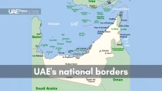
British naval maps from the 1820s finally documented Abu Dhabi’s intricate coastline. Yet local guides still whispered warnings about shifting sand seas no parchment could capture. These early efforts formed a series that balanced European precision with Bedouin land knowledge—a fusion shaping today’s border agreements.
As Al-Idrisi once noted: “The wise traveler listens to both the scholar’s quadrant and the herder’s song.” That blend of methods still defines how we understand this dynamic region.
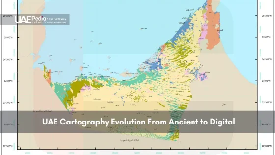
UAE Cartography: From Ancient Techniques to Digital Innovations
Imagine swiping a screen to zoom from camel caravan trails to hyperloop routes in seconds. That’s the leap mapping has taken here—where star charts now share digital space with 3D city models. Today’s tools don’t just show roads; they pulse with real-time water levels, urban expansion alerts, and even desert fox habitats.
Transition from Traditional to Digital Mapping
Gone are the days of inked coastlines fading under desert sun. Abu Dhabi’s Environmental Atlas—a flagship project—layers centuries-old well locations with live satellite feeds. Municipal teams update land use data faster than a sandstorm shifts dunes. Want to compare 1980s fishing villages to today’s islands? Tap the “time slider” on public portals.
Innovations in Digital Cartography Tools
Drones now map mangrove forests millimeter by millimeter, while AI predicts how rising temperatures might redraw the environment. One game-changer: the National Atlas series. Its interactive layers let you toggle between traffic patterns, solar farm sites, and archaeological digs. As a planner told us: “Maps here aren’t snapshots—they’re living stories.”
| Traditional | Digital | Impact |
|---|---|---|
| Hand-drawn grids | GIS overlays | Precision farming |
| Well depth logs | Aquifer sensors | Water conservation |
| Star navigation | GPS drones | Disaster response |
This fusion of old and new does more than guide travelers—it safeguards ecosystems and fuels smart cities. Next time you check a map here, look closer. Those glowing lines carry whispers of Bedouin poets and the hum of servers keeping a nation on course.
Navigating the Geography and Environmental Challenges
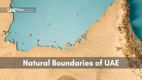
How do you chart a landscape that redraws itself daily? In this sun-baked corner of Arabia, mapmakers face shifting dunes taller than skyscrapers and mountains that shrug off cloud cover. The environment here isn’t just scenery—it’s an active collaborator in every survey.
Impact of Natural Features on Map-making
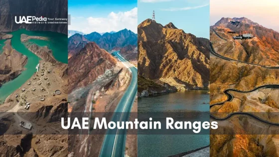
The Hajar Mountains taught early cartographers humility. Their jagged peaks forced mapmakers to invent elevation symbols long before contour lines became standard. Coastal areas presented another puzzle: tidal flats that vanish twice daily required moon-phase annotations on medieval charts.
Modern teams still wrestle with dunes that migrate up to 15 meters yearly. Satellite teams update desert landscapes weekly, while LiDAR-equipped trucks scan wadis after flash floods. As one surveyor joked: “Our maps come with expiration dates.”
Adapting to Harsh Climatic Conditions
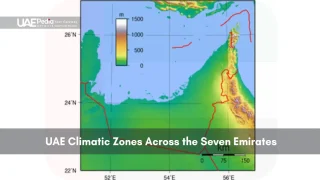
Dust storms that blot out the sun? They’re why today’s digital maps use weather-fed overlays. Water scarcity led to ingenious solutions: ancient well maps now inform AI models predicting aquifer levels. In Abu Dhabi, 3D city models factor in heat radiation patterns to plan cooler neighborhoods.
Check out how traditional wisdom meets tech:
| Challenge | Traditional Fix | Modern Solution |
|---|---|---|
| Shifting sands | Star-aligned stone markers | GPS drift sensors |
| Water sources | Palm trunk maps | Subsurface imaging |
| Mountain passes | Goat-hair trail flags | Drone pathfinding |
These layered approaches don’t just document the environment—they help shape a sustainable future where maps act as blueprints for balancing growth with desert life.
Final Reflections on the Legacy and Future of UAE Cartography
From camel caravans to cloud servers, mapping this region has always been a dance with nature. The united arab emirates’ story reveals how star paths and AI now coexist in tools that guide both explorers and city planners. Bedouin sky wisdom lives on in drones scanning wadis, while ancient well maps inform modern water conservation strategies.
Abu Dhabi’s Environmental Atlas exemplifies this fusion—layering 9th-century trade routes with live climate data. Projects like these honor the arab emirates’ past while tackling desertification and urban sprawl. As one engineer put it: “Our ancestors drew oases; we code them into algorithms.”
Future maps will likely blend holographic city models with real-time sand dune tracking. Yet the core challenge remains unchanged: capturing a country where mountains, coasts, and deserts never sit still. This crossroads legacy, detailed in our exploration of the region’s maritime history, continues to shape priorities from coastal surveys to space-based navigation systems.
Next time you view a digital map here, look for the hidden layers—centuries of ingenuity pressed into pixels, still charting the balance between growth and the fragile land beneath.
Early inhabitants used oral storytelling, star navigation, and etched landmarks on leather or palm leaves. They tracked seasonal water sources like wadis and trade routes—knowledge passed through generations, forming the bedrock of Emirati geographical identity.
Scholars during the Islamic Golden Age refined astrolabes and compiled detailed travel logs. Figures like Al-Idrisi created “Tabula Rogeriana”—a 12th-century world map that documented coastal areas of the Gulf, blending Greek geography with Arab merchant insights.
Shifting dunes, extreme heat, and scarce permanent landmarks require constant updates. Modern mappers use satellite tech to track changes, while historical surveys relied on camel caravans and Bedouin guides to navigate the ever-changing terrain.
Discovering oil reserves sparked detailed geological surveys. British-led teams mapped coastlines and hinterlands, creating infrastructure blueprints that evolved into today’s hyper-detailed city plans for Dubai and Abu Dhabi.
GIS systems, LiDAR scans, and 3D modeling software help design smart cities. Projects like Masdar City integrate real-time environmental data, while apps like “Dubai Now” offer public transit maps updated by the minute—merging tradition with AI-driven precision.
Absolutely! The Qasr Al Watan Library in Abu Dhabi displays rare Ottoman-era maps, while the Sharjah Museums Authority showcases pearl trade routes. Digital archives like the UAE National Atlas also make centuries-old charts accessible online.