Contents
- 1 UAE Tectonic Plates
- 2 Understanding the Regional UAE Tectonic Plates Setting
- 3 Arabian Tectonic Plates Geology
- 4 Unique Features of Arabian Tectonic Plates
- 5 Movements of the Arabian Tectonic Plates
- 6 UAE-Oman Mountains and Oceanic Crust Clues & Mantle Rocks
- 7 Geophysical Data of UAE-Oman Mountains & Oceanic Crust
- 8 Does Dubai Experience Earthquakes?
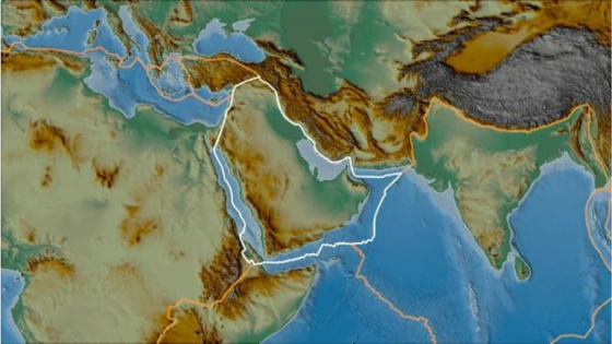
UAE Tectonic Plates are located in the northeast of the Arabian plate and are separated by several well-defined tectonic boundaries. In the southeast, the African plates and Arabian and Eurasian plates diverge over the Gulf of Aden, while the Red Sea spreading boundary forms the plate interface in the southwest. In the northwest, the Dead Sea transform faults skirt the Mediterranean Sea and extend to the Taurus Mountains to the east of the Turkish plate. The Zagros thrust and fold belt, which ends just north of the Persian Gulf’s eastern boundary, defines the Arabian plate’s northern margin.
UAE Tectonic Plates
The Makran subduction zone, where the Arabian Plate tectonic evolution subducts beneath the Eurasian plate, defines the remaining portion of the plate’s northeastern margin. The Owen fracture zone is a transform boundary that separates the Indian and Arabian plates to the east. Aside from these major boundaries, the Arabian Plate is a stable landmass with no visible evidence of interior deformation throughout the late Tertiary. The heartland of the Arabian plate has not undergone any large seismic events in the last 2000 years and may be considered a stable cratonic zone.
At longitudes near the UAE, the Arabian Plate is currently advancing northwards on a bearing of N889 58E at a pace of roughly 2292 mm/year relative to the Eurasian Plate. This convergence is facilitated by a combination of intra-continental shortening throughout Iran along the Zagros fold and thrust belt, as well as the subduction of the Arabian plate beneath the Eurasian plate eastwards of around 588E at the Makran subduction zone in the north of the Gulf of Oman.
The Arabian plate’s regional tectonic setting is defined by the borders indicated above. However, most of these margins are too far away to significantly impact seismic hazards in the UAE. However, this shows the presence of certain active tectonic formations in the Oman Mountains near the UAE. The deformation associated with this mountain range, along with the borders of the Zagros fold and thrust belt and the Makran subduction zone, are the principal seismic sources that are expected to influence the seismic hazard for sites in the UAE.
Read more: UAE Cartography; The Detailed Geography Political UAE Map
Understanding the Regional UAE Tectonic Plates Setting
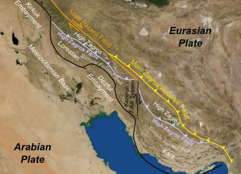
Understanding the regional tectonic background allows one to identify zones where specific kinds of deformation can be expected from the process of tectonic plates shifting over millions of years. However, to assemble a seismic source model for use in a PSHA, a higher level of resolution must be considered, as well as the identification of particular faulting structures that have the potential to cause earthquakes that could harm sites in the UAE.
Unfortunately, the published literature on the geological features of the UAE and the northeastern Arabian Peninsula is extremely limited. Due to a lack of knowledge, it is difficult to determine the nature of structural features in the Oman Mountains and within the Arabian Plate in areas near the study’s sites of interest. In contrast, there are several articles on the peculiar structural characteristics of southern Iran.
Read more: UAE Soil Conservation: Emirates Global Climate Initiative with Sadhguru to Save Soil
Arabian Tectonic Plates Geology
The Arabian plate is approximately 2600 kilometers north-south and 3000 kilometers east-west long, with a thickness of 40 kilometers. The Arabian Shield refers to the upper crust’s crystalline Precambrian basement, which is Neoproterozoic in age (1000–540 Ma). Its lithologies include schists, amphibolites, gneisses, metabasalts, greywackes, cherts, and andesites. The shield is overlain by Phanerozoic sediments (except in the southwest) and Cenozoic flood basalts in the west. This sedimentary/volcanic bundle is known as the Arabian Platform, and it thickens to the east.
The sedimentary rocks are predominantly carbonate and silica formations, with some evaporating. The exposure of the Arabian Shield in the southwest, as well as the thickening of the Arabian Platform towards the east, is typically attributed to uplift caused by rifting in the Red Sea and loading in the north as a result of collision with Eurasia.
Read more: UAE Conservation Biology: United Arab Emirates Winning Wildlife Conservation Efforts
Unique Features of Arabian Tectonic Plates
The essential features of the Arabian tectonic plates are briefly outlined below:
The Hydrocarbon Reservoirs
According to BP’s Statistical Review of World Energy 2013, the Arabian plate now contains 48% of the world’s oil reserves and 43% of the world’s natural gas reserves. The plate’s tectonic history accounts for its oil and gas abundance. The Arabian plate was subjected to approximately 570Ma of practically continuous sedimentation, making it a perfect environment for hydrocarbon formation.
The Seismicity
As previously stated, the Zagros Mountains mark the collision zone between Arabia and Eurasia, and this active convergence causes significant seismic activity in the area. There are frequent earthquakes with surface wave magnitudes of 7.0 and focal depths in the upper 20 km of the crus. The Arabian plate rotates counterclockwise; hence, shortening rates are faster in the southeast than in the northwest. As a result, the SE shortens perpendicular to the trend of the fold-and-thrust belt, whereas the NW collides obliquely with the trend.
The Volcanism
The Arabian plate has large Cenozoic basaltic plateaus known as the Harrats, which stretch parallel to the Red Sea. They cover 180,000 km2 and are related to rifting in the Red Sea during the Oligocene. Harrat Ash Shaam is the largest volcanic province, covering 50,000 km2 and containing pyroclastic cones, shield volcanoes, and hydromagmatic craters. This volcanic field has been divided into two phases of volcanism: the first, which lasted from the late Oligocene to the mid-Miocene and was caused by Red Sea rifting, and the second, which lasted from around 13 Ma to the present and was caused by the Arabian plate’s counterclockwise rotation.
Read more: UAE Climatic Zones: Knowledge Portal to Dubai’s Weather
Movements of the Arabian Tectonic Plates
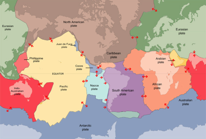
The Arabian Plate is one of the tectonic plates that comprise the Earth’s crust. It advances northeastward as a result of magma eruptions along the Red Sea rift, which spread annually at a pace of about 15 mm. This spreading center generates many earthquakes along its boundaries with the surrounding plates, such as those along its eastern and northeastern margins that form the Zagros Mountains in Iran or along its northern margins in Turkey, which was hit by a devastating earthquake on August 17, 1999, that claimed the lives of nearly 20,000 people, injured more than 40,000, and displaced over a quarter of a million people, in addition to huge material losses, which were estimated.
Saudi Arabia is part of the so-called Arabian Plate. It is surrounded by three types of tectonic boundaries: divergent, convergent, and transform fault lines. The Arabian Peninsula is the largest part of this plate, hence the name. The Arabian Plate is limited from the west by the Red Sea floor spreading zone and from the south by the Gulf of Aden floor spreading zone, with significant portions of the plate in both locations.
The Zagros and Makran Mountains in Iran, as well as the Taurus Mountains in southern Turkey, are the Arabian Plate’s eastern and northern limits, respectively. These are classified as convergent plate boundaries, representing the zone of collision between the Arabian Plate and the Eurasian Plate.
The Arabian Plate is bound from the northwest by the Dead Sea Rift, a left-lateral transform fault boundary that runs from the northern end of the Red Sea to the Taurus Mountains in southern Turkey via the Dead Sea. The Owen Fault, which runs from the eastern end of the Gulf of Aden to the eastern end of the Makran Mountains, is the plate’s southeast boundary.
The Arabian Plate advances northeasterly between the aforementioned transform fault boundaries, resulting in the development of the Red Sea and the Gulf of Aden, as well as plate collisions at the Makran, Zagros, and Taurus mountains. Earthquakes are concentrated along the Arabian Plate’s boundaries. The majority of these earthquakes strike the Gulf of Aqaba, the Dead Sea, the middle of the Red Sea, the Gulf of Aden, and the boundary between the Arabian and Iranian continental plates.
The basement rocks of Saudi Arabia, known as the Arabian Shield, encompass roughly one-third of the Kingdom’s geographical area, while the sedimentary rocks, known as the Arabian Shelf, cover the remainder. The volcanic flows cover a considerable portion of western Saudi Arabia, including the holy towns of Mecca and Madina. Geologic formations like historic and modern surface and subsurface faults and folds are found throughout the kingdom, particularly in the western regions. Some research indicates that some internal regional faults may be extensions of transform faults in the Red Sea.
UAE-Oman Mountains and Oceanic Crust Clues & Mantle Rocks
The UAE-Oman mountains are 150 kilometers wide and span 700 kilometers, exposing the Semail ophiolite thrust sheet, which is approximately 15-20 kilometers thick. Under the remarkably well-preserved Semail ophiolite, a succession of thrust sheets of oceanic sedimentary and basaltic rocks emplaced from northeast to southwest separates the underlying ophiolite from the Arabian continental rocks.
When thick oceanic crust material meets buoyant continental crust material, the oceanic plate often moves beneath the continental plate. It sinks into the mantle through a process called subduction. However, a process known as obduction periodically pushes sheets of oceanic crust and upper mantle materials over less dense continental material.
Although obduction is classified as a geodynamic anomaly, it is not uncommon. Ophiolites, which are sequences of oceanic crust and upper mantle rocks found near continent surfaces, provide evidence of such a mechanism. The Semail ophiolite complex, located in the eastern corner of the Arabian Peninsula and straddling Oman and the United Arab Emirates (UAE), is by far the largest, best exposed, and most investigated.
Although scientists have extensively researched the surface geology of this region, the intermediate to lower crustal structure of the UAE-Oman mountains remains unknown. Despite almost 40 years of intensive geological research, a shortage of high-resolution geophysical imaging beneath the UAE-Oman mountains persists.
Scientists from the Petroleum Institute in Abu Dhabi (UAE) have collaborated with geologists and geophysicists from the University of Oxford to investigate the structure beneath both the Semail ophiolite and the underlying crust of the UAE-Oman mountain range. Their extensive geophysical and geological discoveries make substantial advances toward resolving the current controversies over ophiolite emplacement processes.
Geophysical Data of UAE-Oman Mountains & Oceanic Crust
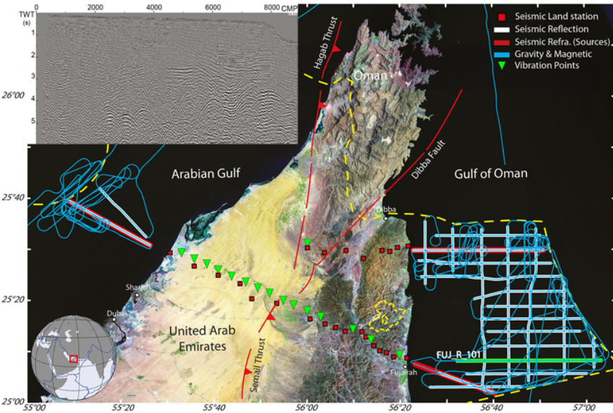
In July 2014, the study team conducted the UAE-Oman region’s first combined seismic reflection and refraction experiment to shed light on the crustal and upper mantle structures beneath the mountains. Passive and active seismic techniques will be utilized to create fresh images of the crust’s structure, which will then be confirmed using potential field modeling (gravity, magnetic). The scientists also intend to collect vibroseis seismic data in early 2016, in which a “thumper truck” causes vibrations in the earth, to supplement the existing data collection.
This satellite image depicts the location of the tests. Shots for the refraction experiment were fired offshore (thick red lines) and recorded on land using broadband seismometers (red squares). White lines denote reflection transects. Gravity and magnetic data (light blue lines) were collected during the cruise. We intend to deploy vibroseis vehicles in numerous areas (green inverted triangles) to supplement the current data set. The yellow dashed line represents the border between the United Arab Emirates (UAE) and other countries, while the bottom left inset displays the UAE’s location. The upper left inset depicts a seismic record for the reflection line FUJ_R_101 (highlighted in green).
The survey ship M/V Hawk Explorer collected seismic reflection data on a 925-kilometer grid in the Arabian Gulf and the Gulf of Oman. The ship towed an array of air guns (with a total volume of 7060 cubic inches, or 116 liters) to generate seismic waves, as well as a 5-kilometer-long multichannel streamer to capture reflections from subseafloor sediments and basement rock. Seismic refraction data were collected along specified reflection lines using 25 broadband land recording stations.
The refraction data consisted of around 800 airgun shots fired at 50-second intervals. Gravity and magnetic measurements were collected continually. According to project experts, the ongoing arguments about ophiolite production and emplacement cannot be resolved without more thorough geophysical and geological measurements. Throughout the cruise,. Similar data will be collected along the east-west onshore refraction transects and combined with existing onshore and offshore datasets.
Broadband seismometers are currently monitoring teleseismic earthquakes more than 1000 kilometers away from the measurement site. The analysis of three-component wavefronts and shear-wave splitting from this data will reveal new information about the deep lithospheric structure and degree of anisotropy, respectively.
Read more: UAE Desert Climate; Guide to Emirates Climate Change and Weather in the United Arab Emirates
Does Dubai Experience Earthquakes?
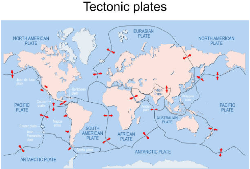
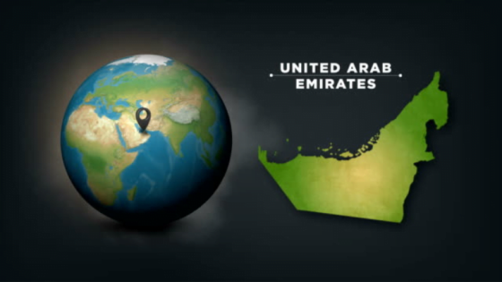
Many cities face the inescapable risk of a major earthquake. Fortunately, Dubai is not located on a fault line, so the probability of an earthquake is quite minimal; however, this does not mean that it does not experience occasional wobbles. The UAE is situated on the edge of the Arabian Tectonic Plate, which pushes against the Eurasian Plate. The Zagros mountain range of Iran, which forms the boundary between those plates, is one of the world’s most seismically active places. As displayed on a globe map with tectonic plates above.
Because of Iran’s proximity to the UAE, when a major earthquake strikes, Dubai usually suffers mild to moderate vibrations. One of the reasons we’re creating this ‘Dubai quake explainer’ is that over the weekend, UAE citizens reported feeling tremors several times after multiple earthquakes devastated southern Iran. According to the UAE’s National Center of Meteorology, two earthquakes with magnitudes of 6.3 occurred in the early hours of Saturday, the first at around 1.32 a.m. local time and the second at 23.24.
Between the two earthquakes, aftershocks of magnitude 4.6 and 4.4 struck at 2.43 and 3.13 a.m., respectively, with aftershocks from the second earthquake felt again at 5.14 and 6.51 a.m. One of the largest earthquakes ever felt in Dubai occurred in April 2013, when a massive 7.8-magnitude earthquake struck the Iran-Pakistan border. Thousands of people were evacuated from high-rise buildings in Dubai as a precautionary measure.
Following the 2013 disaster, Dubai Municipality changed its seismic ordinance, requiring that any new towers with more than ten stories be built to survive a 5.9-magnitude quake. Before this, towers had to be able to resist a moderate earthquake ranging from 5.0 to 5.5.
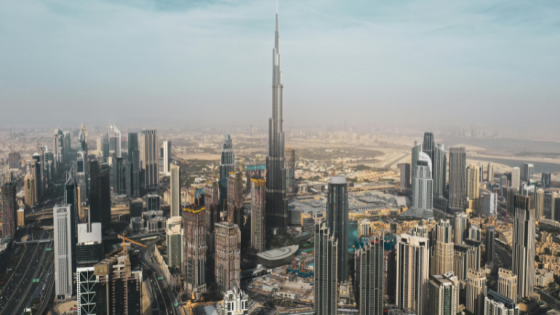
The world’s tallest building, the Burj Khalifa, was built to survive a 7.0 magnitude earthquake. The 828-meter tower even features an earthquake warning system, with sensors located throughout the building that can detect structural movement and assess whether evacuation is required. Dubai also has a network of seismic sensors spread across the emirate, which monitor any unusual activity that could harm the city as a whole.
Read more: UAE Mountains; Emirates Mountains Jebel Jais Hajar Mountain in Ras Al Khaimah
What is the tectonic activity in the UAE?
The majority of documented earthquakes in the region occur in southern Iran, where the Arabian and Eurasian plates intersect. Since 2006, seismic activity in the UAE has been concentrated in the northeastern region, particularly in the Dibba and Masafi-Bani Hamid areas, as well as near the Marghem gas field in Wadi Nizwa.
Is there an Arabian tectonic plate?
The Arabian Plate is one of the tectonic plates that comprise the Earth’s crust. It advances northeastward as a result of magma eruptions along the Red Sea rift, which spread annually at a pace of about 15 mm.
Are there tectonic plates in the Middle East?
The Middle East region has all known forms of major plate borders, as well as ongoing intraplate deformation.
Are there fault lines in the Middle East?
A digital, active tectonic map of the Middle East is created in ArcGIS format. The EMME Project defines 3,397 active fault sections and parameterized faults totaling 91,551 km.
The UAE tectonic plates offer a fascinating glimpse into the dynamic movements of the Arabian plate. This minor tectonic plate, characterized by a divergent plate boundary, has undergone significant changes during various main periods of tectonic activity. Understanding these movements is crucial, as the Arabian plate hosts diverse geological features and seismic activities. By studying the tectonic plates in this region, we can better predict and prepare for potential earthquakes, ensuring the safety and resilience of the communities in the UAE and beyond.
