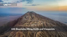
What if every road, building, and park in the Emirates could tell its own story? Since 1971, geospatial data has quietly shaped the nation’s skyline—from desert highways to sustainable smart cities. Today, this invisible grid powers everything from metro routes to renewable energy farms.
Platforms like Union Atlas and 1Map act as digital sandboxes where planners test ideas before breaking ground. Think real-time traffic patterns layered over 3D city models, or climate projections mapped against future neighborhoods. These tools don’t just display maps—they predict outcomes.
Local universities and government teams collaborate like coffee-shop regulars refining their favorite brew. Together, they’ve turned raw satellite feeds into decision-making gold. Need to site a new hospital? The system cross-references population growth, road networks, and emergency response times.
Three things to remember:
- Smart scaffolding: GIS acts as the backbone for sustainable expansion across sectors
- Time travel tools: Historical maps meet future simulations in platforms like 1Map
- Team sport: Every infrastructure win stems from shared data between agencies and researchers
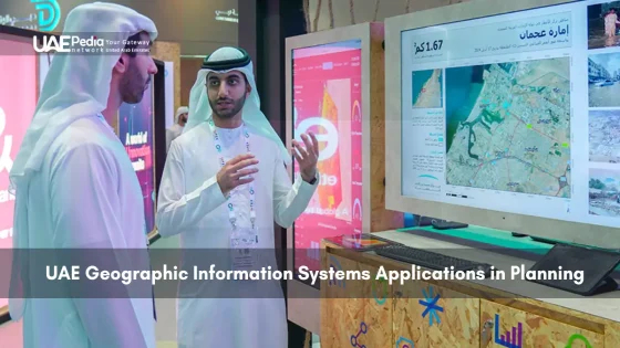
The Role of Geospatial Data and Technology in Modern Planning
Imagine planning a city where every decision is backed by layers of digital insight. That’s what modern geospatial tech brings to the table—think of it as a superhero cape for urban designers. Let’s unpack how these tools work and why they’re changing the game.
Understanding Geographic Information Systems Essentials
At its core, a GIS acts like a digital Swiss Army knife. It layers satellite imagery, population stats, and environmental factors onto interactive maps. The FCSC’s work with ArcGIS shows how merging traffic patterns with school locations can pinpoint where new bike lanes matter most.
Here’s the magic recipe:
- Capture data from drones, sensors, or satellites
- Analyze relationships between housing density and park access
- Visualize results through color-coded heatmaps or 3D models
Mapping Innovations Driving Urban Development
Cities like Abu Dhabi now use real-time dashboards to test infrastructure ideas before breaking ground. One recent project mapped shade patterns across public spaces—helping planners plant trees where pedestrians need relief from the sun.
| Traditional Mapping | Modern GIS | Impact |
|---|---|---|
| Paper blueprints | 3D digital twins | Faster updates |
| Manual surveys | Satellite automation | Cost savings |
| Single-layer data | Multi-source layers | Smarter zoning |
This isn’t just about flashy tech. When Dubai integrated flood-risk data into its metro expansion plans, they avoided future headaches. It’s like having a crystal ball—but powered by bytes, not magic.
Innovative UAE Geographic Information Systems in Urban Development
Picture this: a city that adapts to your needs before you even voice them. That’s the reality taking shape in Abu Dhabi and Dubai, where geospatial data becomes the brushstroke for urban masterpieces. Let’s explore how these emirates turned spreadsheets into skylines.
Desert Metropolis Makeovers
Abu Dhabi’s planners recently used satellite-fed heatmaps to reimagine public spaces. By overlaying foot traffic patterns with sun exposure data, they planted 12,000 trees exactly where shade mattered most. “It’s like giving the city sunglasses,” quips a local engineer involved in the project.
Dubai took it further, integrating flood-risk analysis into metro expansions. Their GIS models predicted drainage needs for 2045 rainfall scenarios—avoiding future chaos. This forward-thinking approach mirrors the collaborative spirit seen in the national geospatial data platform, where agencies share live updates like neighbors swapping recipe tips.
Smart Cities, Smarter Partnerships
Private tech firms now co-design interactive dashboards that make urban planning feel like playing SimCity—but with real-world impact. One partnership birthed a 3D map tracking energy use across 50+ high-rises, slashing consumption by 18% through targeted retrofits.
- Real-time traffic sensors adjusting signal timings during peak hours
- Waste management routes optimized via daily population density maps
- Construction sites monitored through AI-processed satellite imagery
As one Dubai official puts it: “We’re not just building cities—we’re coding them.” With every layer of spatial data, these urban hubs rewrite the rules of what a metropolis can become.
Enhancing Infrastructure and Transportation Through GIS
How do you solve a traffic jam before it happens? Planners here use geospatial data like chefs use recipe apps—combining real-time ingredients to serve smoother commutes. Let’s explore how invisible data layers shape the roads and rails beneath our feet.
When Maps Talk Back
The FCSC’s 1Map platform acts like a traffic crystal ball. During Dubai Metro’s recent expansion, planners overlaid population stats with existing rail routes. Result? New stations now connect bus stops to metro lines like puzzle pieces snapping into place. One engineer shared: “We spotted a 23% commuter overlap before pouring concrete—saved months of adjustments.”
Data-Driven Detours
Abu Dhabi’s spatial data program transformed highway planning. Their dashboards blend truck traffic patterns with accident statistics. Last year, this helped reroute 15% of freight vehicles away from school zones during peak hours. Key tools making it work:
- Live sensors updating road conditions every 90 seconds
- 3D models testing bridge heights against future sea levels
- Shared portals where logistics firms suggest route tweaks
| Traditional Approach | GIS Advantage | Outcome |
|---|---|---|
| Fixed bus schedules | Real-time rider density maps | Dynamic shuttle routes |
| Manual traffic counts | AI-processed camera feeds | Faster signal adjustments |
| Paper zoning maps | Interactive land-use layers | Smarter mixed-use districts |
These aren’t just tech upgrades—they’re teamwork turbochargers. When a new freight corridor opened last month, planners and trucking companies co-designed exit ramps using shared spatial analysis tools. Less honking, more high-fives.
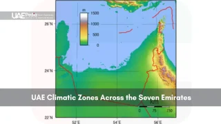
GIS Applications in Environmental Management and Sustainable Development
Ever wonder how tech keeps deserts green and cities clean? Meet the silent guardians—satellite eyes and smart maps working overtime. The Environmental Geospatial Platform acts like a nature documentary director, zooming in on ecosystems from orbit to sidewalk level.
Leveraging Satellite Imagery for Environmental Monitoring
Picture drones mapping coral reefs while AI scans for pollution patterns. Last year, researchers used satellite imagery to track mangrove growth along coastlines—spotting a 14% expansion since 2020. “It’s like having x-ray goggles for the planet,” says a conservationist using these tools daily.
Here’s how it works:
- Daily snapshots from space flag illegal landfills
- Heat sensors detect underwater oil spills invisible to boats
- Historical data layers predict wildfire risks
Supporting Sustainable Development and Green Initiatives
Urban planners now play matchmaker between concrete and chlorophyll. One project merged biodiversity maps with construction zones, saving 8 protected species habitats. The secret sauce? Open-access spatial data that lets everyone from students to mayors join the green team.
| Challenge | GIS Solution | SDG Impact |
|---|---|---|
| Air quality decline | Real-time pollution heatmaps | Healthier cities (Goal 3) |
| Soil erosion | Erosion risk models | Life on land (Goal 15) |
| Energy waste | Solar potential mapping | Affordable energy (Goal 7) |
As one environmental officer shared: “We’re not just planting trees—we’re coding forests.” From tracking endangered species to zoning eco-friendly neighborhoods, these tools turn green dreams into grid coordinates.
Empowering Research and Academic Excellence in Geospatial Studies
Where do you train the mapmakers of tomorrow? Universities here blend classroom theory with real-world challenges—like coding labs that feel more like innovation hubs. Imagine classrooms buzzing with students overlaying population stats on 3D city models or debating climate solutions using live satellite feeds.
Graduate Programs Driving GIS Research
The University of Sharjah’s MSc in Geospatial Information Systems and Remote Sensing (GISRS) shows how academia fuels progress. Students tackle projects like optimizing solar farm layouts using spatial data and AI—skills that land them roles at tech giants or urban planning agencies. One recent grad shared: “We didn’t just study maps—we redesigned how cities breathe.”
Programs thrive on cross-pollination. Engineering students collaborate with environmental scientists to model coastal erosion, while computer science teams refine data analysis tools for municipal use. The RISE research initiative takes it further, pairing learners with industry mentors on projects ranging from smart agriculture to disaster response simulations.
Cutting-edge facilities act as sandboxes for innovation. Think drone labs capturing centimeter-precise terrain scans, or VR setups where students “walk” through proposed infrastructure designs. Courses balance technical rigor with creative problem-solving—like a statistics class that uses real-time traffic patterns to teach predictive modeling.
Career paths? Graduates shape futures as urban intelligence specialists, environmental impact analysts, or geospatial tech entrepreneurs. With demand for GIS professionals growing 22% annually nationwide, these programs don’t just teach skills—they launch trailblazers.
“Our labs are bridges between theory and action,”
Ready to join the journey? Whether you’re analyzing migration trends or coding the next mapping platform, geospatial studies offer a passport to shaping tomorrow’s landscapes—one layered dataset at a time.
Collaborative Innovations: Government and Private Sector in GIS
What happens when city planners and tech wizards swap coffee breaks for data streams? The answer lies in partnerships reshaping how we map progress. Public agencies and private innovators now co-create tools that turn raw numbers into urban solutions—like chefs collaborating on a signature dish.
Fostering Data Integration and Public-Private Partnerships
The FCSC’s 1Map platform shows how teamwork turbocharges results. By merging municipal statistics with private-sector analysis, this shared dashboard lets planners and startups solve puzzles together. Think of it as a digital potluck—everyone brings their best data dish to the table.
Three ingredients make these collaborations sizzle:
- Standardized formats letting traffic systems “talk” to utility networks
- Live dashboards where logistics firms suggest route tweaks in real time
- Open APIs inviting app developers to build on public spatial data
One recent win? A joint project cut hospital response times by 18% using shared intelligence layers. As a tech lead involved shared: “We spotted ER demand patterns the health ministry missed—like finding hidden doors in a maze.”
These alliances prove management isn’t about control—it’s about connection. When private firms access live zoning maps, they propose smarter warehouse sites. When agencies tap startup algorithms, they predict traffic snarls before honking begins. The result? Cities that evolve faster than rush hour.
“Shared data turns ‘my problem’ into ‘our solution.'”
Technological Trends and Future Innovation in Geospatial Mapping
What if maps could think for themselves? Tomorrow’s geospatial tools are evolving from static charts to living ecosystems. The FCSC’s latest ArcGIS upgrades reveal a world where machine learning spots traffic bottlenecks before drivers do—and where satellites predict solar farm outputs like weather forecasts.
Machine Learning Meets Earth Observation
Big data isn’t just big—it’s lightning-fast. New algorithms chew through satellite feeds and population stats simultaneously, spotting patterns humans might miss. One recent project used AI to map rooftop solar potential across entire cities in hours, not months.
| Old Approach | New Tech | Impact |
|---|---|---|
| Monthly reports | Real-time dashboards | Faster decisions |
| Manual analysis | Self-teaching models | Lower costs |
| Single-use data | Cross-sector intelligence | Smarter policies |
Global Race for Smarter Solutions
Nations now compete to build the sharpest geospatial services. The country’s data maturity initiatives—like training 500+ specialists annually—position it as a hub for next-gen mapping. “We’re not just keeping up,” shares an FCSC strategist. “We’re rewriting the rulebook.”
Clickable Worlds Transform Decisions
Interactive platforms turn citizens into planners. Cloud-based systems let anyone layer flood risks over school zones or simulate green space impacts. During recent flood tests, emergency teams used shared 3D maps to coordinate rescues 40% faster.
“These tools don’t just show data—they spark ‘aha!’ moments.”
From predictive analysis guiding metro expansions to AI-powered management of water networks, the future feels closer than ever. And with every innovation, the invisible grid beneath our cities grows smarter.
Looking Ahead: Shaping Tomorrow’s Urban Landscapes with GIS
What if cities could learn from their own heartbeat? Tomorrow’s urban spaces will pulse with data-driven intelligence, transforming how we live and move. Integrated mapping platforms now fuel smarter decisions across sectors—from optimizing bus routes to predicting neighborhood energy needs.
Key breakthroughs emerge when spatial data meets teamwork. Abu Dhabi’s tree-planting initiative and Dubai’s flood-ready metro show how shared analysis creates resilient cities. These successes hint at a future where real-time population trends shape everything from hospital placements to park designs.
Three shifts will redefine urban growth:
- Living dashboards: Municipal services adjust dynamically using traffic patterns and air quality feeds
- Citizen coders: Residents propose zoning tweaks through public mapping tools
- Climate armor: 3D models test infrastructure against rising temperatures and sea levels
Collaboration remains the secret sauce. As seen in strategic infrastructure ventures, blending government vision with private-sector tech sparks innovation. Picture logistics firms and urban planners co-designing freight corridors using shared intelligence layers.
The road ahead? Cities that don’t just grow—they adapt. With every layer of geospatial insight, we’re not just planning spaces. We’re crafting ecosystems where business thrives, communities connect, and deserts bloom. Ready to help code this future? Your next idea might just redraw the map.
Think of it as a digital twin—layering population stats, traffic patterns, and infrastructure maps to model future neighborhoods. Dubai’s “Smart City” dashboards use real-time spatial analysis to optimize everything from metro routes to green spaces, blending satellite imagery with on-ground sensors.
Absolutely! Satellite monitoring tracks coastal changes and desertification, while heat maps identify urban areas needing more shade. Abu Dhabi’s Environment Agency uses geospatial data to protect mangroves and plan solar farms—turning raw stats into actionable green strategies.
Collaboration. Federal hubs like the Geospatial Analytics Platform integrate data from energy, health, and transport sectors into one interactive system. Private firms add hyperlocal details—imagine combining Emirates Red Crescent flood reports with ride-hailing app traffic flows during emergencies.
Big time! Universities like Khalifa University offer specialized geospatial degrees, while agencies like Dubai Municipality run training programs. From analyzing smart meter networks to designing drone-powered 3D city models, skilled mappers are in high demand across sectors.
Every brick’s plotted digitally. Masdar’s team simulated wind patterns and sun exposure to orient buildings for natural cooling, while IoT sensors now adjust energy use hourly. It’s GIS meets sci-fi—proving sustainable design starts with precision mapping.
Yes—and it’s getting easier. Open portals like Dubai Pulse share zoning maps and demographic insights, letting cafes scout foot traffic hotspots or delivery apps optimize routes. Some datasets require permits, but the trend leans toward transparent, crowd-updated info.
Watch for AI crunching satellite feeds to predict construction delays or coral bleaching. Emirates like Sharjah are testing AR apps that overlay utility lines onto real-world views for repair crews. The future? Faster, greener decisions powered by maps that think.