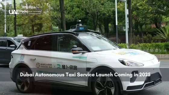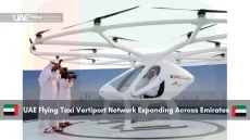
What if your morning commute could swap bumper-to-bumper traffic for a smooth glide above skyscrapers? The Emirates is turning this vision into reality through a revolutionary project charting three-dimensional pathways through the sky. Think of it as subway lines for the atmosphere—a network designed for both piloted air taxis and autonomous cargo drones.
Collaborators like the General Civil Aviation Authority and Technology Innovation Institute are crafting smart regulations alongside digital maps. Their goal? To ensure these flying vehicles coexist safely with traditional aircraft while zipping between neighborhoods and business hubs.
This isn’t just about cool tech—it’s practical magic. Picture faster emergency response times, streamlined deliveries, and commutes measured in minutes rather than hours. Existing road networks would breathe easier too, easing congestion in rapidly growing cities.
Here’s what you need to know:
- A groundbreaking initiative to map sky routes for next-gen vehicles
- Human-operated and self-flying systems working in harmony
- Strategic partnerships ensuring safety meets innovation
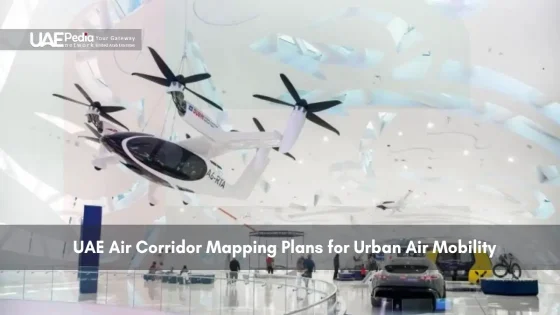
Overview of UAE Air Corridor Mapping Plans
Imagine a sky crisscrossed with invisible highways where delivery drones and passenger craft zip silently overhead. This ambitious project reimagines cityscapes by creating three-dimensional travel networks connecting major hubs and cultural landmarks. Think less traffic lights, more digital flight paths guiding vehicles from takeoff to touchdown.
Setting the Stage for Urban Air Innovation
Local visionaries are crafting a mobility platform that feels straight out of sci-fi—but with concrete goals. Safety and sustainability form the bedrock, with real-time monitoring systems preventing mid-air tangos between drones and helicopters. “We’re not just building routes,” shares a project lead, “we’re coding courtesy into the clouds.”
Key Objectives and Expected Outcomes
The blueprint focuses on three pillars:
- Smart regulations allowing different vehicle types to share airspace
- Energy-efficient flight patterns reducing urban carbon footprints
- Public-private partnerships accelerating tech adoption
Early trials suggest commutes between business districts could shrink from 45 minutes to 12. Emergency responders might gain vital extra minutes reaching crises. Best part? These skyways could eventually handle 30% of ground traffic volume during peak hours.
The Evolution of Urban Air Mobility in the UAE
Decades ago, camels roamed these sands—now autonomous taxis might soon rule the skies. This transformation from desert trails to digital flight paths reveals how visionary thinking reshapes how we move. Collaborators like the Technology Innovation Institute (TII) and ASPIRE didn’t just wake up to this reality; they built on lessons from early experiments in smart infrastructure.
From Sand Dunes to Smart Cities
The 2000s saw the first steps: GPS-guided systems for emergency helicopters, followed by drone delivery trials in the 2010s. “Every falcon’s flight taught us about wind patterns,” notes an aviation historian. Those insights now fuel AI systems predicting turbulence and optimizing battery life for electric vertical takeoff vehicles.
Recent breakthroughs tackle urban challenges head-on. Sensor networks detect building heights in real time, while machine learning adjusts flight paths during sandstorms. Check out how transport priorities shifted:
| Era | Focus | Tech Leap |
|---|---|---|
| 2000s | Emergency Response | GPS Navigation |
| 2010s | Delivery Drones | Battery Efficiency |
| 2020s | Passenger Taxis | AI Collision Avoidance |
Tomorrow’s Solutions, Today’s Foundations
Urban environments demand clever fixes. Think modular vertiports atop parking garages, or noise-reduction tech keeping skies serene. One prototype cargo drone even mimics desert foxes—using heat-resistant materials to handle summer temperatures.
But it’s not all smooth flying. Balancing rapid development with safety tests patience. Regulators juggle public trust and innovation speed, while engineers combat signal interference in dense neighborhoods. Yet each solved puzzle inches us closer to skies buzzing with purpose—not chaos.
Strategic Collaborations Driving Advanced Air Mobility
Ever wondered who’s steering the flying taxis of tomorrow? Behind every drone’s flight path and AI-powered safety protocol stands a dream team of innovators. The Emirates’ skyway revolution thrives on partnerships that blend sharp policy-making with bleeding-edge tech.
Partnerships Between GCAA, TII, and ASPIRE
Think of this trio as the Avengers of urban mobility. The General Civil Aviation Authority (GCAA) sets the rules, while the Technology Innovation Institute (TII) codes the future. ASPIRE? They’re the matchmakers connecting bright ideas with real-world testing grounds.
His Excellency Saif Mohammed Al Suwaidi, GCAA’s Director General, puts it plainly: “Our role isn’t to clip wings—it’s to ensure every ascent is safer than the last.” This philosophy fuels their work on piloted autonomous air systems, where human oversight meets machine precision.
Roles of Regulators and Industry Leaders
Dr. Najwa Aaraj of TII compares her team’s AI navigation tools to “digital falconers”—guiding vehicles through thermal currents and skyscraper canyons. Meanwhile, ASPIRE’s trials turn parking lots into vertiport prototypes, proving concepts before they hit mainstream skies.
Three keys unlock this collaboration:
- Shared data pools predicting weather and traffic patterns
- Real-time communication protocols between drones and control towers
- Public demonstrations building trust in piloted autonomous air travel
As the Director General notes, “True progress flies on two engines: technology innovation and public confidence.” With each test flight, that trust grows—along with the blueprint for cities worldwide.
Regulatory Framework for Piloted and Autonomous Air Taxis
Who decides the rules when taxis take to the skies? Crafting guidelines for flying vehicles isn’t just about traffic lights—it’s about reimagining safety for a three-dimensional world. The challenge? Ensuring human-operated and self-flying systems share space without mid-air surprises.
Developing Safe and Sustainable Guidelines
Regulators and tech teams collaborate like orchestra conductors—harmonizing innovation with responsibility. “Every rule must serve two masters,” explains a policy architect. “Progress needs room to soar, but never at the cost of public trust.” Their playbook covers everything from emergency landing protocols to noise limits near schools.
Sustainability threads through every decision. Battery charging stations double as storm shelters for drones. Flight paths avoid migratory bird routes during nesting seasons. Even software updates get scrutiny—no vehicle lifts off without passing virtual stress tests.
Technical and Compliance Considerations
Behind the scenes, engineers tackle puzzles worthy of spy novels. How do you track a drone in a sandstorm? What happens if two autonomous taxis request the same landing pad? Solutions emerge through:
- Geofencing tech creating digital “no-fly zones” around sensitive areas
- Universal signal languages letting different vehicle brands communicate
- Redundant power systems ensuring safe landings during outages
Compliance isn’t paperwork—it’s peace of mind. Regular audits check everything from cybersecurity to battery disposal. The result? A framework where innovation thrives responsibly, paving the way for skies filled with purpose rather than chaos.
Integration of Piloted and Autonomous Air Taxis and Cargo Drones
Picture a city where your takeout arrives by drone while your neighbor flies home in a taxi above. This isn’t fantasy—it’s the future being built through smart coordination between human pilots and AI systems. The magic lies in blending old-school aviation know-how with cutting-edge autonomy.
Leveraging Advanced Air Mobility Technologies
Think of the sky as a chessboard where every move matters. Advanced routing algorithms act like grandmasters, directing cargo drones through thermal updrafts while reserving lower altitudes for taxis carrying passengers. “Our AI doesn’t just avoid collisions,” explains a systems engineer. “It choreographs aerial ballets where every vehicle knows its part.”
Three tech pillars make this possible:
| Traditional Systems | Integrated Approach | Benefit |
|---|---|---|
| Fixed flight paths | Dynamic routing | 30% faster deliveries |
| Manual coordination | Machine-to-machine chat | Zero communication lag |
| Separate networks | Shared data clouds | 15% energy savings |
Innovative Solutions for Urban Transportation
Morning rush hour reveals the system’s genius. Cargo drones ferry urgent medical supplies between hospitals while taxis shuttle commuters to business hubs—all sharing real-time weather updates. During peak hours, autonomous vehicles handle repetitive routes, freeing human pilots for complex tasks.
The results speak volumes:
- Package delivery windows shrink from hours to 22 minutes
- Shared vertiports reduce infrastructure costs by 40%
- AI redistributes traffic flow during sandstorms
As one logistics CEO puts it: “We’re not replacing drivers—we’re giving them superpowers.” From e-commerce giants to emergency services, everyone gains when skies become collaborative spaces rather than chaotic voids.
Innovative Airspace Management and Corridor Mapping Techniques
Think of tomorrow’s sky traffic as a symphony—each vehicle hitting its note at the perfect moment. This harmony comes alive through smart systems balancing efficiency and safety. At its core? A digital maestro conducting fleets of flying vehicles through invisible pathways.
Cutting-Edge AI and Communication Algorithms
Picture AI that thinks like a seasoned pilot and chats like a telecom expert. TII’s neural networks crunch real-time data—weather patterns, battery levels, even surprise pigeon flocks—to chart optimal paths. “Our algorithms don’t just react,” shares a systems architect. “They anticipate hiccups before they happen.”
These systems excel at three tasks:
- Translating wind gusts into route adjustments milliseconds before impact
- Assigning priority lanes for emergency responders during rush hour
- Creating temporary detours when sandstorms roll in
Optimizing Routes and Ensuring Collision Avoidance
Traditional air traffic control meets its match with dynamic corridor mapping. Sensors on skyscrapers feed live updates to drones, while machine learning predicts traffic snarls. The result? Routes that adapt like water flowing around rocks.
Check out how next-gen navigation stacks up:
| Traditional Systems | Smart Solutions | Impact |
|---|---|---|
| Fixed altitude zones | 3D corridor layering | 45% more vehicles per air mile |
| Radar-based tracking | Blockchain flight logs | Zero unverified movements |
| Manual rerouting | Self-healing networks | 12% fewer weather delays |
Want to see these systems in action? Explore our deep dive into the sky highways initiative shaping urban mobility. From hospital deliveries to sunset commutes, every flight becomes a thread in a grand safety net—woven by code, guided by care.
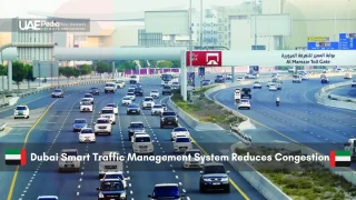
Addressing Urban Connectivity and Infrastructure Challenges
Ever feel like city streets are playing a never-ending game of Tetris? Traditional roads struggle under growing populations and delivery demands. Morning gridlock isn’t just frustrating—it’s costly. Businesses lose hours to delayed shipments, while emergency vehicles inch through traffic. This is where smarter transportation solutions enter the chat.
Mitigating Urban Congestion through Aerial Corridors
Picture delivery drones whisking packages overhead while commuter taxis glide above tangled intersections. These sky routes act like pressure valves for ground networks—diverting 20-30% of traffic upward. “We’re not eliminating roads,” explains an urban planner involved in the sky corridor initiative. “We’re giving cities room to breathe.”
The ripple effects? Faster ambulance arrivals, lunch orders landing warm, and workers reclaiming hours once lost in transit. Neighborhoods previously isolated by highways could gain direct sky links to business hubs. Even garbage trucks might swap narrow alleys for efficient aerial routes.
Key moves making this possible:
- Retrofitting rooftops as mini vertiports for seamless transfers
- Priority lanes for medical and essential deliveries
- Integrating piloted taxis with autonomous systems for flexible scaling
This isn’t a solo mission. Tech firms, urban designers, and community groups co-create these networks—proving that enhancing urban mobility works best when everyone’s invited to the blueprint.
uae air corridor mapping plans as a Catalyst for Smarter Cities
What if skylines could evolve as dynamically as the communities beneath them? The Emirates’ groundbreaking mobility project isn’t just changing how we move—it’s reshaping how cities think. By weaving aerial networks into urban blueprints, neighborhoods gain new dimensions of accessibility while reducing strain on aging infrastructure.
Transforming the Urban Fabric with Integrated Mobility
Picture this: delivery drones ascending from rooftop hubs as commuter taxis glide toward solar-powered vertiports. These three-dimensional transit layers let cities grow upward instead of outward. Barcelona’s superblocks and Singapore’s IoT-enabled streets show how tech can redefine spaces—now imagine adding altitude to the equation.
Key urban shifts emerge through smart design:
| Traditional Cities | Smart Cities | Impact |
|---|---|---|
| Single-level transit | Multi-layered mobility | 28% faster commutes |
| Fixed zoning | Adaptive land use | 15% less sprawl |
| Road-dependent | Hybrid infrastructure | 40% lower emissions |
Urban planner Layla Al-Mansoori observes: “We’re not just building routes—we’re coding flexibility into concrete.” Rooftop gardens double as drone landing pads. Underground parking becomes micro-vertiports. Every innovation tightens the weave between ground and sky.
These solutions spark chain reactions. Faster emergency response times save lives. Last-mile delivery networks boost local businesses. Commuters trade gridlock for productive hours. Best part? The blueprint adapts as needs evolve—future-proofing cities without tearing down the past.
From Barcelona’s sensor-laden sidewalks to Tokyo’s underground bike highways, history shows that mobility revolutions redefine urban life. Now, layered transit networks promise to write the next chapter—one where cities breathe easier, quite literally, as skies become partners in progress.
Economic Growth and Global Trends in Urban Transportation
How do cities stay ahead when tomorrow’s commute demands fresh solutions today? Forward-thinking regions are rewriting the playbook, blending economic strategy with skyward ambition. At the heart of this shift lies a simple truth: mobility isn’t just about movement—it’s about momentum.
Establishing a Benchmark for Future Urban Mobility
This initiative isn’t just building routes—it’s crafting an economic engine. Analysts predict a 17% boost in logistics efficiency within next months of full implementation, with job creation spanning tech sectors and infrastructure roles. “Cities that master layered transit networks,” notes a Dubai-based economist, “will dominate 21st-century trade routes.”
Look at Dublin’s recent pilot: aerial delivery networks reduced downtown truck traffic by 40% while boosting same-day commerce. Similar projects in Singapore and Tokyo show how smart transportation systems become talent magnets—attracting startups and investors alike.
Comparative International Insights and Trends
Global cities face shared challenges:
- London’s congestion pricing funds electric vertiport development
- Seoul integrates drone taxis with its subway network
- Miami’s hurricane-response drones inspire emergency logistics models
What sets this project apart? Speed. Within next months, phased rollouts will test cargo routes and passenger services simultaneously—a gamble that could redefine urban development timelines. As one New York planner admits: “We’re watching closely. This could shortcut years of bureaucratic gridlock.”
The ripple effects extend beyond asphalt. Real estate near vertiports gains value, while retailers rethink inventory strategies for aerial deliveries. It’s not just about flying cars—it’s about designing cities where economic growth and daily life soar together.
Embracing a Connected Future: Shaping Tomorrow’s Urban Mobility Infrastructure
Tomorrow’s cities won’t just rise—they’ll take flight. Picture morning commutes where autonomous air taxis glide alongside cargo drones, all guided by AI that thinks three moves ahead. This isn’t sci-fi; it’s the blueprint for urban living being coded today.
Advanced air mobility solutions are stitching together neighborhoods like never before. Piloted systems and self-flying vehicles share digital highways, while machine learning optimizes routes in real time. “We’re not replacing roads,” explains a tech lead involved in the initiative. “We’re giving cities a third dimension to grow into.”
Three breakthroughs make this possible:
- AI-driven airspace management preventing mid-air tangos
- Battery tech enabling longer flights between charges
- Universal communication protocols letting different vehicle types “talk”
As these systems mature, they’ll reshape global standards. Cities once choked by traffic could see emergency response times halved and delivery networks supercharged. The ripple effects? Cleaner skies, quieter streets, and commutes measured in minutes rather than hours.
This revolution asks us to rethink what urban life can be. Not just smarter cities—but cities that breathe, adapt, and soar. The runway’s clear. All we need to do is board.
The General Civil Aviation Authority (GCAA) is designing layered air corridors with AI-powered traffic management systems. These zones separate piloted vehicles from autonomous drones, ensuring safe integration while adapting to real-time conditions like weather or emergencies.
ASPIRE, Abu Dhabi’s advanced tech program, collaborates with TII and GCAA to test AI algorithms for route optimization. Their work focuses on collision avoidance, energy efficiency, and seamless coordination between ground infrastructure and aerial networks.
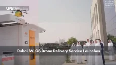
Absolutely! Dubai plans dedicated “sky lanes” for delivery drones by 2025. These routes will connect logistics hubs like Jebel Ali Port with urban centers, reducing road congestion and enabling 24/7 medical supply deliveries to hospitals.
Routes avoid residential zones during nighttime, and electric vertical takeoff (eVTOL) vehicles use whisper-quiet propulsion. The GCAA’s noise mitigation guidelines ensure communities beneath flight paths experience minimal disruption.
Yes—Dubai’s RTA aims for app-based booking similar to Careem. Visitors can hop between landmarks like Burj Khalifa and Palm Jumeirai via pre-mapped tourist corridors, with fares integrated into Nol card payment systems.
While Singapore focuses on port-linked cargo drones, the UAE emphasizes mixed-use corridors blending tourism, logistics, and emergency services. Unlike LA’s single-operator models, Emirati regulations encourage partnerships between Etihad Aviation, SkyGo, and global startups.
All vehicles require triple-redundant navigation systems and parachute deployment capabilities. The GCAA mandates live data streaming to control centers, enabling instant rerouting if sensors detect anomalies mid-flight.